
Unless noted otherwise, the following photographs are postcards* that I purchased.
If possible, I have taken a current photograph from the same angle.
*Unless noted otherwise, credit for the postcards goes to WALCOTT & SONS of San Angelo.
NOTE: Date when postcard photographs were taken were not provided.
Written on back of first postcard below: STREET SCENE, SAN ANGELO, TEXAS Looking east on W. Beauregard St., the first building on the right is San Angelo National Bank. The dominant building in the background is the First Savings and Loan Building. The city is fortunate in having three lovely lakes and numerous beautiful streams within and adjacent to it.
 Above photograph provided by Terry Casey 2011 (October) showing what this area looks like now.
Cathye Moon providedthe below top postcard (on eBay); actual photographer of postcard is UNKNOWN. Date is also unknown – Looking east on Beauregard where Sears became the Public Library (now relocated up the street). Above photograph provided by Terry Casey 2014 (September) showing what this area looks like now.
SKYLINE VIEW OF SAN ANGELO, TEXAS In the foreground are the Municipal Pool Park and the North Concho River. This is just one of the many parks in the city of San Angelo. In the background is the downtown business area of the city. The city itself is surrounded with three lakes and six rivers and creeks. Photograph provided by Terry Casey 2011 (October) – Grass was removed and the River Stage was built and stairs in foreground leading up to Art Museum (behind you). This portion of the Concho River was drained to prepare for bank stabilization work.
STREET SCENE, SAN ANGELO, TEXAS Looking north on So. Chadbourne Street. Located in the land of beautiful running streams and noted for its three picturesque lakes, San Angelo is the world’s largest inland wool shipping center. Above photograph provided by Terry Casey 2011 (October) – What this area looks like now.
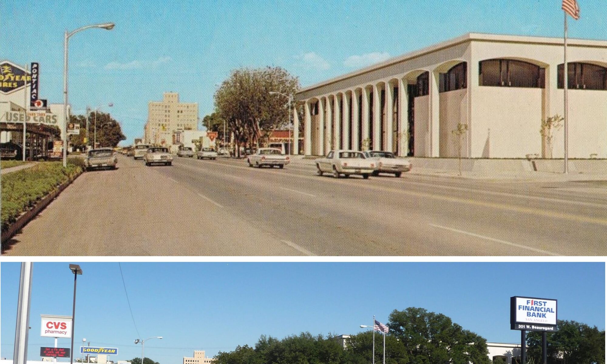
Central National Bank and Street Scene Located downtown San Angelo, Texas. Central National has one of the newest and most modern buildings in San Angelo. San Angelo’s main industries are ranching, farming, oil, and manufacturing. Is the world’s largest inland wool shipping center. Above photograph provided by Terry Casey 2011 (October) – What this area looks like now.
Angelo State University ASU – “Home of the Rams” San Angelo, Texas The local state-sponsored university began in 1928 as San Angelo College, but became Angelo State University in 1969. Angelo State University campus covers 268 acres with the enrollment of about 6,000 students. Above photograph provided by Terry Casey 2011 (October) – What this area looks like now.
GENERAL OFFICES GENERAL TELEPHONE COMPANY OF THE SOUTHWEST HQs for GTC of the Southwest are located in San Angelo, Texas. The company serves over 775,000 telephones located in over 435 towns in Texas, New Mexico, Oklahoma, Arkansas and Louisiana. Above photograph provided by Terry Casey 2011 (October) – What this area looks like now.
LAKE NASWORTHY Located 9 miles south of San Angelo, Texas. Practically all the water used in San Angelo comes from Lake Nasworthy. It belongs to the city of San Angelo. Lots around the lake can be leased from the city for a very low figure. Fishing is very good. Boating and skiing are also enjoyed on this lake. Above photograph provided by Terry Casey 2013 – On our final approach to the airport, I tried to get a good photograph of the dam.
Photograph provided by Ken Grimm Date unknown. This photograph was taken roughly 180 degrees from the previous photographs.
PLAYLAND PARK Located in the heart of downtown San Angelo, on the banks of the beautiful North Concho River, between the Oakes Street Bridge and the Chadbourne Street Bridge. This amusement park is one of the best equipped in this entire area. It has numerous rides for all ages, and is a favorite family spot. The park has a concession stand and has plenty of resting areas. (Terry says: I knew it as Neff’s Park.) Above photograph provided by Terry Casey 2011 – Playland Park/Neff’s Park is no more.
I am assuming this postcard below was printed in 2001 or 2002 shortly before Ernie Baker closed the park. 
RIVER TERRACE, SAN ANGELO, TEXAS Pictured in the background is the River Terrace, an exclusive apartment complex, located on the banks of the beautiful Concho River, near downtown. Santa Fe Park, in the foreground, located in the heart of the city, adjacent to the No. Concho River, affords a peaceful respite from the city’s activities, with benches and picnic areas overlooking the river. A nine hole golf course is also situated in the park. Above photograph provided by Terry Casey 2011 (October) – What this area looks like now. River Terrace Apartments in background.
HEADQUARTERS OF THE 6940TH SECURITY WING U. S. 87 SOUTH, SAN ANGELO, TEXAS This building is located on the south part of the base. It is the main office of the wing commander. The jet in the foreground is a F-100A Super Sabor. For many years it was a pilots training base. Now it is a security training school. Headquarters of Goodfellow Air Force Base.
GOODFELLOW AIR FORCE BASE U. S. 87 SOUTH, SAN ANGELO, TEXAS This base was started June, 1940. The base was named after Lt. James J. Goodfellow of San Angelo. For many years it was a pilots training base. They conduct Training in various technical skills used by the United States Air Force Security Service. The second photograph was taken in2009 – where old North Gate use to be.
|

Goodfellow AFB F-4 Phantom Jet San Angelo, Texas Date Unknown – However, you can see the fence was still up around the school house compound when this photograph was taken. Above photograph provided by Terry Casey (I think) August 2010 – No longer is a fence around the “schoolhouse”.
MATHIS FIELD MUNICIPAL AIRPORT SAN ANGELO, TEXAS Located 10 miles south of San Angelo, near Lake Nasworthy. In the foreground is one of the Texas International Airline Jets. In the background are the airport building and tower. Above photograph provided by Terry Casey. Tall tower is off camera on right.
Currently flights in and out of San Angelo (SJT) are only by American Eagle from its hub in Dallas/Fort Worth (DFW).
On the back of this postcard, there no date when the Administration Building was taken. CURTEICHCOLOR 3-D NATURAL COLOR REPRODUCTION (REF. U. S. A. PAT. OFF.) and DISTRIBUTED BY DEL-TEX, INC., SAN ANGELO-ODESSA, TEXAS Photographs provided by Terry Casey 2010 (August) – Angelo State University Administration Building
FORT CONCHO MUSEUM Located in San Angelo, Texas. It is one of the most interesting of all Texas institutions. It is housed in the old Administration building of Fort Concho which was maintained until 1889 as a military out-post for protection from the Indians. The museum has thousands of very interesting items. Don’t miss seeing it. Open daily for the public.
SAN ANGELO, TEXAS, SKYLINE VIEW In the foreground you are looking at beautiful North Concho River. In the background is the downtown business area of the city. San Angelo is the world’s largest inland wool shipping center. Its main industries are ranching, farming, oil, and manufacturing. It is also the home of Goodfellow Air Force Base. Also, check out: https://www.youtube.com/watch?v=h253uzZezeY&feature=em-subs_digest
TWIN MOUNTAINS Located 10 miles west of San Angelo, used as a landmark for the early settlers. These are near Twin Butte Reservoir shore line. San Angelo is the world’s largest inland wool shipping center. Its main industries are ranching, farming, oil, and manufacturing. Fishing and hunting are also very good.
Lake Nasworthy and Beautiful Homes These are just a few of the homes built around Lake Nasworthy. Lots around the lake can be leased from the city for a very low figures. Practically all the water used in San Angelo comes from Lake Nasworthy. Boating and fishing are enjoyed on the lake year round.
The following photographs are just interesting “stuff” about, around, or in San Angelo (or the Surrounding area).
The below photograph provided by Terry Casey 2012 (March) – Photograph was from one of the many banners around town (not a postcard).
On the back, there was no date nor who(m) to give credit for this postcard photograph.
Photograph provided by West Texas Collection at Angelo State University Flood of May 1957 – Looking SE, between S. Chadbourne and S. Irving (which is totally underwater), the minature golf course (in oval) is under water.
Photograph provided by West Texas Collection at Angelo State University Flood of May 1957 – Looking NW, between S. Chadbourne and S. Oakes, Neff’s Amusement Park is under water.
Photograph provided by Ken Grimm Date unknown.

